


Les Perrons

Specialized77
User GUIDE
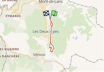

Length
7.6 km

Max alt
1920 m

Uphill gradient
389 m
Km-Effort
12.8 km

Min alt
1659 m

Downhill gradient
388 m
Boucle
Yes
Creation date :
2020-08-23 11:50:52.584
Updated on :
2020-08-23 15:53:02.388
3h21
Difficulty : Medium

FREE GPS app for hiking
 SityTrail
IGN / Geographical institutes
SityTrail Plus
The world is yours!
About
Trail Walking of 7.6 km to be discovered at Auvergne-Rhône-Alpes, Isère, Les Deux Alpes. This trail is proposed by Specialized77.
Positioning
Country:
France
Region :
Auvergne-Rhône-Alpes
Department/Province :
Isère
Municipality :
Les Deux Alpes
Location:
Unknown
Start:(Dec)
Start:(UTM)
273799 ; 4989137 (32T) N.
Comments